
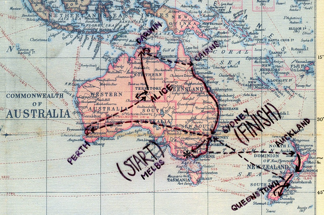
(START)
Melbourne
flew: San Francisco > Melbs
worked: 3 months in Melbs
roadtripped: up to Sydney (coastal route)
roadtripped: down to Melbs (inland route)
flew: Melbs > Auckland
roadtripped: down the North Island to Wellington (inland route)
roadtripped: down the South Island to Queenstown (coastal route)
flew: Christchurch > Sydney
flew: Sydney > Perth
worked: 2.5 months in Perth
flew: Perth > Alice Springs
roadtripped: west to Kings Canyon & Ayers Rock
roadtripped: east to Alice Springs & up to Darwin
worked: 9 weeks in Jabiru
flew: Darwin > Cairns
roadtripped: down to Byron Bay (coastal route)
road the rails: down to Sydney (coastal route)
(FINISH)
Sydney
That's awesome. I did the same. I like ur page
ReplyDeleteWhat an A W E S O M E " Journey".
ReplyDeleteYes Shelz, It was not the "Destination"
It was indeed the Journey...
@Anonymous: Hmm, do I know you?! @SKP: You're absolutely right, it's all about the journey....! Too many people these days focus on the destination! What up with that?!
ReplyDelete